The Maltonian Web
ARCHIVE PAGE: this website is gradually being updated from May 2022
Examination papers
On this page is a transcript of a 1932 School Certificate Geography exam.
Also available as pdfs are:
- 1949 School Certificate Arithmetic
- 1949 School Ceretificate English
- 1951 GCE Advanced Biology
- 1951 GCE Advanced Physics
Geography Exam
Thursday 7 July 1932, 2 - 5 pm
UNIVERSITIES OF MANCHESTER, LIVERPOOL, LEEDS, SHEFFIELD, AND BIRMINGHAM.
SCHOOL CERTIFICATE AND
MATRICULATION EXAMINATIONS
THREE HOURS
Begin each question on a fresh page.
Candidates must answer SIX questions in all, which must include Question 1 and at least ONE from each of Sections A, B and C. Where appropriate, simple sketch-maps or diagrams should be included.
1.Study the Ordnance Map provided and answer the following questions:-
(a) Describe the position of Weston-super-Mare and state what appears to be its advantages as a health and pleasure resort.
(b) Describe the physical conditions which help to explain (i) why the larger settlements in the Axe valley lie to the north rather than to the south of the river Axe, (ii) why there is no significant settlement along the estuary of this river.
(c) Comment upon (i) the general absence of watercourses in the uplands extending from Uphill (C2) eastwards across the map, (ii) the course of the river Axe between Crabhole (D4) and the western margin of D4.
(d) How does the coast on the south side of Brean Down (C1) differ in character from the coast in the neighbourhood of Brean (D1)
(e) Give the geographical definitions of (i) the natural feature which extends from Crook Peak (D4) south eastwards to Dunnett Farm, (ii) the natural feature used by the railway and road in passing southwards from C5 to D5.
SECTION A.
A2. On the sketch-map of the world provided:
(a) Mark Lat. 50° N. and Long. 0°.
(b) The mean sea-level isotherm for a certain month is drawn for the northern hemisphere. Write along the isotherm (i) the name of the month, and (ii) the temperature.
(c) By means of the capital letters given in brackets mark the positions of the Black Sea (B) Cook Strait (C), Iceland (1), Java (J), Korea (K), Panama Canal (P).
On the lines provided at the foot of the map :
(a) Name the particular branch of pastoral fanning which prevails in the areas shaded on the map, and
(b) Give reasons for your decision.
A3. Choose one of the climatic stations given below and state, giving your reasons, whether you consider the station to be (i) in the Northern or in the Southern Hemisphere, (ii) between or outside the Tropics. Describe the chief features of the climate and suggest a possible location for the station selected.
| Altitude in feet | Jan | Feb | Mar | Apr | May | June | July | Aug | Sep | Oct | Nov | Dec | |
| A 840 | °F | 12 | 15 | 28 | 46 | 58 | 67 | 72 | 70 | 60 | 48 | 31 | 19 |
| In | 0.9 | 0.8 | 1.6 | 2.3 | 3.6 | 4.4 | 3.4 | 3.5 | 3.4 | 2.3 | 1.3 | 1.1 | |
| B 36 | °F | 67 | 66 | 65 | 61 | 59 | 56 | 55 | 56 | 58 | 59 | 62 | 64 |
| In. | 0.0 | 0.0 | 0.6 | 0.2 | 3.5 | 5.8 | 4.8 | 3.2 | 0.8 | 0.4 | 0.1 | 0.3 | |
(Temperatures given are reduced to sea-level. Rainfall is given in inches.) |
|||||||||||||
A4. Either
Describe the natural vegetation which is characteristic of (a) hot grasslands, (b) temperate grasslands, (c) tundra.
Or
Indicate as accurately as you can the location of three large inland drainage basins. Describe and give reasons for the existence of one of these basins and comment upon its value to man.
SECTION B
B5. Draw a large sketch-map of one of the following coal-mining areas, showing the positions of its principal towns : (a) Lanark (Clyde), {b) Northumberland and Durham, (c)Yorks., Derby, and Notts. Name one important manufacturing industry of the area chosen, and state the factors which have contributed to its development.
B6. Choose one town from each of the following pairs, and, in each case, (a) describe its position and (b) indicate the geographical conditions which have contributed to its importance: (i) Carlisle, Crewe; (ii) Dublin, Bristol; (iii) Edinburgh, York.
B7. Give a reasoned account of the distribution and density of population in (a) the North West Highlands of Scotland, and {b) Norfolk and Suffolk.
SECTION C
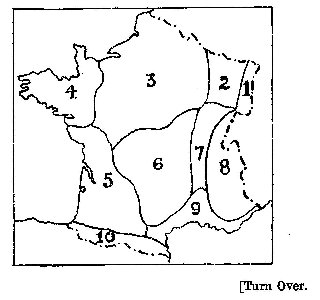
C8. Describe the principal occupations of the inhabitants of any two of the regions marked on the accompanying map of France, and state how these occupations are influenced by geographical factors.
C9. Indicate the influence of the gold and diamond resources of the Union of South Africa upon (a) the distribution of population and (b) the railway system of the Dominion.
C10. State how far geographical considerations have helped to determine the distribution of population in either Brazil or Chile.
C11. Explain why irrigation, is necessary in the Punjab and in the Deccan. Distinguish and account for the type of irrigation which is characteristic of each area.
C 12. Describe and give reasons for the position and extent of each of two of the important crop belts of the Central Lowlands of North America.
Name one important town in each of the belts chosen and account for its importance.
C 13. Under the headings (a) position, (b) relief, (c) climate, (d) products, write an account of one of the following: Denmark, Egypt, Newfoundland, Queensland, Yangtse-kiang Basin.